-40%
USGS 5 Bulls Hardback MANHATTAN NY, CORUNDUM in US, VERMONT, WISCONSIN, All MAPS
$ 35.9
- Description
- Size Guide
Description
SCARCE HARD COVER!! CHOICE BULLETINS IN ONE VOLUME!!Here is an interesting opportunity. This is a nice hard cover containing five USGS Bulletins in one volume. They are:
USGS Bulletin 269,
The Occurrence and Distribution of Corundum in the United States
175 pages
USGS Bulletin 270,
The Configuration of the Rock Floor of Greater New York
96 pages
USGS Bulletin 271,
Bibliography and Index of North American Geology, Paleontology, Petrology, and Mineralogy for the Year 1904
218 pages
USGS Bulletin 272,
Taconic Physiography
52
pages
USGS Bulletin 273,
The Drumlins of Southeastern Wisconsin
46
pages
I would picture this as appealing most especially to residents of New York (especially New York City), Massachusetts, or Vermont.
These bulletins were originally issued in paper covers whose acidic paper rarely stood up over time. To find these in a hard cover and well preserved is unusual. The photos are in the order of the bulletins as described.
Descriptions of each one are below.
USGS Bulletin 269,
Corundum and Its Occurrence and Distribution in the United States.
Published in 1906, this is a rare bulletin I have never had before. It is an expanded edition of Bulletin 180 from 1901 (see my other listings for a hard cover of Bulletin 180 alone). This
175-page
bulletin comes with the foldout map of Montana corundum occurrences, including the Yogo sapphires and others, a foldout map of corundum occurrences in the US, and a
foldout map showing peridotites in the eastern US. There are also numerous photographs of locations, mines, and features of significance, plus additional maps within the text itself.
This book focuses on corundum occurrences in a belt from Alabama to New Jersey, with emphasis on the more significant deposits in North Carolina and Georgia, as well as several occurrences in Montana. Minor attention is given to occurrences in other areas. Some of the significant areas discussed include:
Montana:
Rock Creek
Yogo
Cottonwood Creek
North Carolina:
Sheffield mine
Buck Creek
Jackson county
Georgia:
Laurel Creek mine
Track Rock mine
Foster mine
Other areas in:
Pennsylvania
Montana
Emery occurrences in:
New York
Massachussets
North Carolina
Plus a few others
This bulletin is packed with interesting information on the geology, history, production and uses of corundum. Some of this information is not readily available elsewhere.
USGS Bulletin 270,
The Configuration of the Rock Floor of Greater New York
.
Published in 1906, this is another rare bulletin I have never had before, and especially interesting. This one is 96 pages and comes complete with four interesting maps:
A fold out of Lower Manhattan island with streets and bed rock contours.
A similar single page map of Upper Manhattan island
A fold out showing a longitudinal cross-section of the bedrock and overlying units along Manhattan island
A fold out showing cross sections at several notable locations in the New York area, such as Park Ave bridge, Washington bridge, and some other locations that may not exist any more.
This study was done in part to support design and construction of the subway system in New York. It is a pretty cool old bulletin, and is a great piece of both the history and geography/geology of New York City. The maps are tipped into the binding, which means there is a tab on the back of the maps that stands them out from the binding, allowing them to be removed without loss, or viewed in their entirety without anything lost from view in the crease. I'm not in favor of maps being removed from books for framing but I recognize it takes place and is a driver of pricing on these.
This bulletin contains information about the rock units comprising bedrock, as well as the less consolidated formations overlying the bedrock. The picture that emerges is of an uneven, dissected bedrock surface that has been filled in with later sediments. Who knew the basement was that complex? A rare bulletin I have never had or offered before.
USGS Bulletin 271,
Bibliography and Index of North American Geology, Paleontology, Petrology, and Mineralogy for the Year 1904.
Not going to spend much time on this! It is 218 pages of blibliographic information. There you go! I doubt it would be of much interest today.
USGS Bulletin 272,
Taconic Physiography.
I have had this one before as a stand alone volume and it is a really nice bulletin.
Published in 1905,
It c
onsists of the 52-page text and all four of the maps, which are shaded relief maps or topographic maps. One of the maps is a large foldout map, shown in the pictures. The other three are single page size, one of which is shown above. This book describes the physical features of this area bordering the east side of the Hudson River in
Massachusetts, New York, and southern Vermont
. Pittsfield is toward the south end of the large map. Crown Point on Lake Champlain is at the north end.
In addition to interesting descriptions of the area at the time, this contains numerous photos and drawings of significant features in the area. Among these are Haystack mountain, the Taconic and Green Mountain ranges, Two Tops, Vermont Valley, a geologic cross section of the region, a map of the Lower Course of the Hoosic river at Schaghticoke, another map of of the east bank of the Hudson near Melrose, a sketch of Monument Mountain, a photo of the Falls of the Poesten Kill, a photo of "The Gorge" at Pittsford, Vermont, a Map near Mount Greylock, another of part of Equinox Mountain, a photo of "The Hopper", photos of the mountains near Wallingford, as well as both a map and a photo of Lake Dunmore and Silver Lake, Vermont.
This book relates the physical features of the area to the geologic history and structures, including older folding of the rocks and younger glaciation. It is fairly easy reading. The maps, photos, drawings and diagrams are all very nice, and have a very old, vintage look to them, and although I hate to say it, these kinds of maps and the like are often removed and framed. Fortunately, this is complete, looking to be preserved rather than dissected. It would make a great contribution to any library on the area.
USGS Bulletin 273,
The Drumlins of Southeastern Wisconsin.
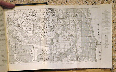
This bulletin, published in 1905, contains 46 pages and one nice fold out map of SE Wisconsin, plus several photos and diagrams of drumlins, their topographies, and internal features. The map covers from Lake Michigan west to Madison, and from Kenosha north to about Germantown. The drumlins show the direction of glacial flow and are one of the key indicators of how glaciation progressed in the region. A fairly interesting study, in which one guy studied about 1400 of the things, and summarized the results in this bulletin.
Expert packing assured. Shipping weight is three pounds. The recent increase in postage rates was pretty big. As a result, Media Mail is now my default shipping method to keep shipping affordable.
Visit my store,
Rockwiler Books and Minerals.
I will continue to add items to my store, so check back frequently.
®
ROCKWILER


